Geolocate

Boyceville topographic map

Click on the map to display elevation.

About this map

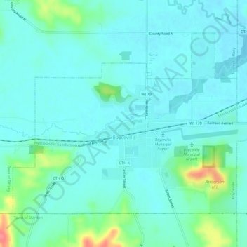
Name: Boyceville topographic map, elevation, terrain.

Location: Boyceville, Dunn County, Wisconsin, 54725, United States (45.03120 -92.06631 45.06033 -92.01008)

Average elevation: 297 m

Minimum elevation: 283 m

Maximum elevation: 356 m

Other topographic maps

Click on a map to view its topography, its elevation and its terrain.

Graytown

United States > Wisconsin > Dunn County

Average elevation: 344 m

Caryville

United States > Wisconsin > Dunn County

Average elevation: 241 m

Downsville

United States > Wisconsin > Dunn County

Average elevation: 255 m

Rock Falls

United States > Wisconsin > Dunn County

Average elevation: 265 m

Wilson Park

United States > Wisconsin > Dunn County > Menomonie

Average elevation: 267 m

Canary Island

United States > Wisconsin > Dunn County > Menomonie

Average elevation: 309 m

Gear up for your next adventure:

🔥Camping Stove - Portable stoves to cook outdoors with ease
🚲Handlebar Phone Mount - View topographic-map.com live while cycling
🥾Hiking Gaiters - Protect legs and shoes from mud, snow, and debris
🔦LED Headlamp - Hands-free lighting for early morning starts or late finishes
🧦Thermal Socks - Warm socks for winter hiking or camping

As an Amazon Associate, this site earns from qualifying purchases at no extra cost to you.