Geolocate

Virú topographic map

Click on the map to display elevation.

About this map

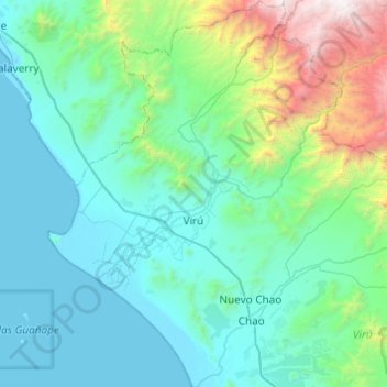
Name: Virú topographic map, elevation, terrain.

Location: Virú, Province of Virú, La Libertad, Peru (-8.62248 -78.93509 -8.14070 -78.55038)

Average elevation: 589 m

Minimum elevation: -2 m

Maximum elevation: 3,753 m

Other topographic maps

Click on a map to view its topography, its elevation and its terrain.

El Paraíso

Peru > La Libertad > Rázuri

Average elevation: 22 m

Abdon

Peru > La Libertad > Longotea

Average elevation: 2,919 m

Curva de Sun

Peru > La Libertad > Curva de Sun

Average elevation: 16 m

Gear up for your next adventure:

🥾Mountain Hiking Shoes - Shoes with superior grip for mountainous terrain
🎒Hiking Daypack - Lightweight and durable backpacks for day trips and excursions
🔭Compact Binoculars - Lightweight optics for scouting trails and wildlife
🌬️Windproof Camp Stove - Efficient cooking even on exposed mountain peaks
🥾Trail Running Shoes - Lightweight and durable shoes for trail running

As an Amazon Associate, this site earns from qualifying purchases at no extra cost to you.