Geolocate

Frieri topographic map

Click on the map to display elevation.

About this map

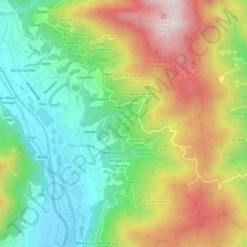
Name: Frieri topographic map, elevation, terrain.

Location: Frieri, Villar Perosa, Torino, Piedmont, 10069, Italy (44.90257 7.24015 44.94257 7.28015)

Average elevation: 753 m

Minimum elevation: 468 m

Maximum elevation: 1,159 m

Gear up for your next adventure:

🧥Thermal Layer - Insulating layer for cold outdoor conditions
🔥Camping Stove - Portable stoves to cook outdoors with ease
🛶Canoe Life Vest - Safety vest for water sports
🦌Outdoor Trail Camera - Monitor wildlife activity near your favorite spots
🔭Outdoor Binoculars - Lightweight binoculars for birdwatching and hiking

As an Amazon Associate, this site earns from qualifying purchases at no extra cost to you.