
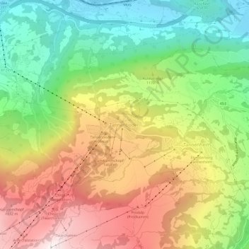
Tannenboden topographic map
Interactive map
Click on the map to display elevation.
About this map
Name: Tannenboden topographic map, elevation, terrain.
Average elevation: 1,102 m
Minimum elevation: 422 m
Maximum elevation: 1,933 m
Other topographic maps
Click on a map to view its topography, its elevation and its terrain.
Quarten
Suisse > Saint-Gall > Wahlkreis Sarganserland
Quarten, Wahlkreis Sarganserland, Saint-Gall, Suisse
Average elevation: 1,283 m
Sargans
Suisse > Saint-Gall > Wahlkreis Sarganserland
Sargans, Wahlkreis Sarganserland, Saint-Gall, 7320, Suisse
Average elevation: 707 m
Mels
Suisse > Saint-Gall > Wahlkreis Sarganserland
Mels, Wahlkreis Sarganserland, Saint-Gall, Suisse
Average elevation: 1,317 m