Geolocate

A Coruña topographic map

Click on the map to display elevation.

About this map

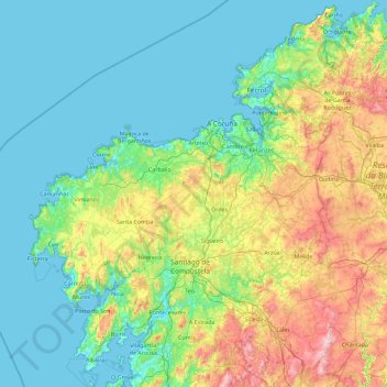
Name: A Coruña topographic map, elevation, terrain.

Location: A Coruña, Galicia, Spain (42.46292 -9.30154 43.79042 -7.66180)

Average elevation: 225 m

Minimum elevation: -3 m

Maximum elevation: 1,142 m

Other topographic maps

Click on a map to view its topography, its elevation and its terrain.

Praia de Queiruga

Spain > Galicia > Noia > As Chamosas

Average elevation: 45 m

Gear up for your next adventure:

🥾Waterproof Trail Shoes - Shoes designed to handle wet terrain
🦟Insect Repellent - Keep mosquitoes and black flies away in wooded areas
👟Leg Gaiters - Keep debris, mud, and snow out of your boots
🧦Hiking Liner Socks - Thin base layer to prevent friction and blisters
🧥Softshell Hiking Jacket - The perfect balance of wind protection and breathability

As an Amazon Associate, this site earns from qualifying purchases at no extra cost to you.