Geolocate

Aboite topographic map

Click on the map to display elevation.

About this map

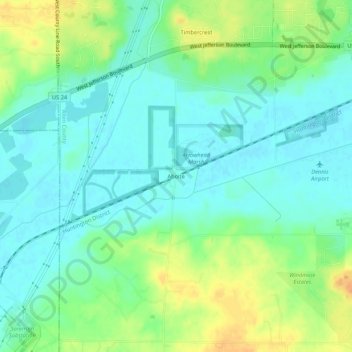
Name: Aboite topographic map, elevation, terrain.

Location: Aboite, Allen County, Indiana, 46783, United States (40.98088 -85.33803 41.02088 -85.29803)

Average elevation: 239 m

Minimum elevation: 226 m

Maximum elevation: 265 m

Other topographic maps

Click on a map to view its topography, its elevation and its terrain.

Leo-Cedarville

United States > Indiana > Allen County

Average elevation: 245 m

Monroeville

United States > Indiana > Allen County

Average elevation: 242 m

Woodburn

United States > Indiana > Allen County

Average elevation: 228 m

New Haven

United States > Indiana > Allen County

Average elevation: 237 m

Gear up for your next adventure:

🦌Outdoor Trail Camera - Monitor wildlife activity near your favorite spots
🧦Hiking Socks - Moisture-wicking and comfortable socks for long hikes
🧴Bear Spray Holster - Quick-access carry for essential Canadian wilderness safety
🔦UV Flashlight - Detect minerals or specific insects in the dark
🧊Insulated Water Bottle - Keeps drinks cold in summer and prevents freezing in winter

As an Amazon Associate, this site earns from qualifying purchases at no extra cost to you.