Geolocate

Paramoti topographic map

Click on the map to display elevation.

About this map
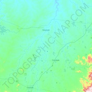
Name: Paramoti topographic map, elevation, terrain.

Location: Paramoti, Região Geográfica Imediata de Canindé, Região Geográfica Intermediária de Fortaleza, Ceará, Northeast Region, Brazil (-4.29059 -39.57007 -4.04678 -39.15549)

Average elevation: 154 m

Minimum elevation: 63 m

Maximum elevation: 819 m

Other topographic maps

Click on a map to view its topography, its elevation and its terrain.
Buenos Aries

Brazil > Ceará > Alcântaras

Average elevation: 743 m

Machuca

Brazil > Ceará > Aquiraz

Average elevation: 19 m

Gear up for your next adventure:

🥽Outdoor Goggles - Protective eyewear for outdoor activities
🧦Merino Wool Socks - Moisture-wicking comfort for long-distance hiking
⛺Backpacking Tent - Lightweight tent for long-distance hiking trips
🧥Softshell Hiking Jacket - The perfect balance of wind protection and breathability
🔭Outdoor Binoculars - Lightweight binoculars for birdwatching and hiking

As an Amazon Associate, this site earns from qualifying purchases at no extra cost to you.