
Campoalegre topographic map
Click on the map to display elevation.
About this map
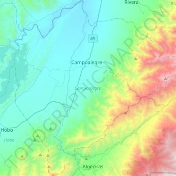
Name: Campoalegre topographic map, elevation, terrain.
Location: Campoalegre, Norte, Huila, RAP (Especial) Central, Colombia (2.51027 -75.43892 2.78109 -75.17014)
Average elevation: 1,063 m
Minimum elevation: 458 m
Maximum elevation: 3,072 m
Other topographic maps
Click on a map to view its topography, its elevation and its terrain.
Altamira
Altamira is a small pueblo in the department Huila, with a population around 2,416. Its geographical coordinates are 2° 3' 46" North, 75° 47' 14" West. It is about an 8-hour bus trip south of Bogota. The largest city in Huila and its capital is Neiva, which is 89 miles north, with a population of about…
Average elevation: 1,032 m