Geolocate

Willow topographic map

Click on the map to display elevation.

About this map

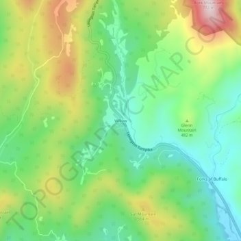
Name: Willow topographic map, elevation, terrain.

Location: Willow, Amherst County, Virginia, United States (37.67041 -79.26114 37.71041 -79.22114)

Average elevation: 454 m

Minimum elevation: 266 m

Maximum elevation: 775 m

Gear up for your next adventure:

Camping Coffee Maker - Brew fresh coffee anywhere on the topographic map
🎒Hiking Backpack - Lightweight and ergonomic backpacks for day hikes or multi-day treks
🥽Outdoor Goggles - Protective eyewear for outdoor activities
🧭GPS Outdoor Watch - Smart watch for navigation and fitness tracking in nature
🥾Mountain Trail Shoes - High-traction shoes for mountain trails

As an Amazon Associate, this site earns from qualifying purchases at no extra cost to you.