Geolocate

Copper Mountain topographic map

Click on the map to display elevation.

About this map

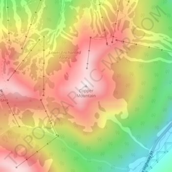
Name: Copper Mountain topographic map, elevation, terrain.

Location: Copper Mountain, Summit County, Colorado, United States (39.46895 -106.15714 39.46905 -106.15704)

Average elevation: 3,483 m

Minimum elevation: 3,104 m

Maximum elevation: 3,787 m

Other topographic maps

Click on a map to view its topography, its elevation and its terrain.

Dillon

United States > Colorado > Summit County

Average elevation: 2,796 m

Silverthorne

United States > Colorado > Summit County

Average elevation: 2,858 m

Blue River

United States > Colorado > Summit County

Average elevation: 3,075 m

Gear up for your next adventure:

🥾All-Terrain Hiking Boots - Versatile boots for varied hiking conditions
🧥Ultralight Puffy Jacket - Maximum warmth that packs down to the size of an orange
🧥Waterproof Jacket - Lightweight rain jackets for hiking and outdoor activities
🔦LED Headtorch - Bright and durable light for night activities
🧼Travel Hand Sanitizer - Keep hands clean when water is scarce

As an Amazon Associate, this site earns from qualifying purchases at no extra cost to you.