Geolocate

Hutthurm topographic map

Click on the map to display elevation.

About this map

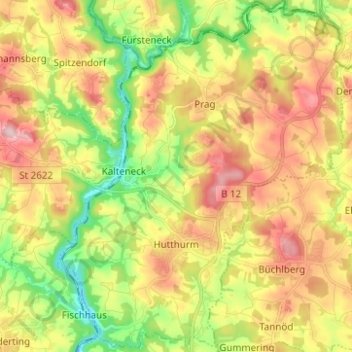
Name: Hutthurm topographic map, elevation, terrain.

Location: Hutthurm, Landkreis Passau, Bavaria, 94116, Germany (48.64715 13.43014 48.72911 13.53114)

Average elevation: 432 m

Minimum elevation: 317 m

Maximum elevation: 556 m

Other topographic maps

Click on a map to view its topography, its elevation and its terrain.

Rohrbach

Germany > Bavaria > Landkreis Passau > Hörmannsdorf

Average elevation: 402 m

Penning

Germany > Bavaria > Landkreis Passau > Karpfham Bahnhof

Average elevation: 357 m

Muth

Germany > Bavaria > Landkreis Passau > Loizersdorf

Average elevation: 474 m

Gear up for your next adventure:

🧰Survival Kit - Essential gear for emergencies in the wilderness
🥫Freeze-Dried Meals - Lightweight, high-calorie nutrition for multi-day treks
🥾Hiking Shoes - Durable and comfortable shoes for trail hiking
💧Filtered Water Bottle - Safe drinking water on the go
🔋Emergency Crank Radio - Weather alerts and power without needing batteries

As an Amazon Associate, this site earns from qualifying purchases at no extra cost to you.