Geolocate

Rio da Onça topographic map

Click on the map to display elevation.

About this map
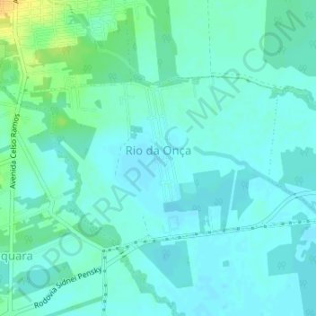
Name: Rio da Onça topographic map, elevation, terrain.

Location: Rio da Onça, Garuva, Região Geográfica Imediata de Joinville, Região Geográfica Intermediária de Joinville, Santa Catarina, Região Sul, 89248-000, Brasil (-26.05982 -48.85728 -26.04312 -48.82508)

Average elevation: 9 m

Minimum elevation: 2 m

Maximum elevation: 29 m

Other topographic maps

Click on a map to view its topography, its elevation and its terrain.
Tijuco Preto

Brasil > Santa Catarina > Garuva

Average elevation: 1,269 m

Morro da Igrejinha

Brasil > Santa Catarina > Garuva

Average elevation: 1,228 m

Rio Braço

Brasil > Santa Catarina > Garuva

Average elevation: 47 m

Pico da Jurema

Brasil > Santa Catarina > Garuva

Average elevation: 922 m

Monte Crista

Brasil > Santa Catarina > Garuva

Average elevation: 628 m

Gear up for your next adventure:

🔋Emergency Crank Radio - Weather alerts and power without needing batteries
🧭GPS Outdoor Watch - Smart watch for navigation and fitness tracking in nature
🧴Outdoor Sunscreen - High SPF protection for high-altitude UV exposure
🥾Hiking Shorts - Breathable shorts suitable for summer hikes
👟Trail Running Shoes - Agile footwear for fast-paced topographic exploration

As an Amazon Associate, this site earns from qualifying purchases at no extra cost to you.