
Make a donation
Gear up for your next adventure:
As an Amazon Associate, this site earns from qualifying purchases at no extra cost to you.
Aaron Mercer Reservoir topographic map
Click on the map to display elevation.
Make a donation
Gear up for your next adventure:
As an Amazon Associate, this site earns from qualifying purchases at no extra cost to you.
About this map
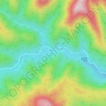
Name: Aaron Mercer Reservoir topographic map, elevation, terrain.
Location: Aaron Mercer Reservoir, Polk County, Oregon, United States (44.90322 -123.48803 44.90658 -123.46958)
Average elevation: 367 m
Minimum elevation: 213 m
Maximum elevation: 623 m
Make a donation
Gear up for your next adventure:
As an Amazon Associate, this site earns from qualifying purchases at no extra cost to you.
Other topographic maps
Click on a map to view its topography, its elevation and its terrain.
Willamette River
United States > Oregon > Polk County
The Willamette River drains a region of 11,478 square miles (29,730 km2), which is 12 percent of the total area of Oregon. Bounded by the Coast Range to the west and the Cascade Range to the east, the river basin is about 180 miles (290 km) long and 100 miles (160 km) wide. Elevations within the watershed…
Average elevation: 72 m