Geolocate

Alcorneo topographic map

Click on the map to display elevation.

About this map

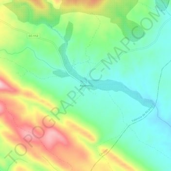
Name: Alcorneo topographic map, elevation, terrain.

Location: Alcorneo, Valencia de Alcántara, Cáceres, Extremadura, España (39.28204 -7.21286 39.32204 -7.17286)

Average elevation: 416 m

Minimum elevation: 325 m

Maximum elevation: 578 m

Gear up for your next adventure:

🥾Trail Hiking Shoes - Durable shoes designed for rugged trails
🔭Compact Binoculars - Lightweight optics for scouting trails and wildlife
🔦UV Flashlight - Detect minerals or specific insects in the dark
🧤Rechargeable Heated Gloves - Extreme warmth for Canadian winter expeditions
🏕️Camping Hammock - Integrated protection for sleeping between trees

As an Amazon Associate, this site earns from qualifying purchases at no extra cost to you.