Geolocate

León topographic map

Click on the map to display elevation.

About this map

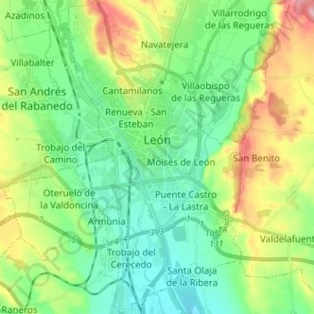
Name: León topographic map, elevation, terrain.

Location: León, Castile and León, Spain (42.54693 -5.63080 42.64035 -5.53378)

Average elevation: 855 m

Minimum elevation: 797 m

Maximum elevation: 983 m

Other topographic maps

Click on a map to view its topography, its elevation and its terrain.

Quintanilla de Somoza

Spain > Castile and León > Luyego

Average elevation: 1,079 m

Valduga

Spain > Castile and León > Robleda

Average elevation: 809 m

Gear up for your next adventure:

🥾Approach Boots - Comfortable boots for hiking and climbing approaches
🦟Insect Repellent - Keep mosquitoes and black flies away in wooded areas
🛏️Camping Sleeping Mat - Comfortable mats for sleeping outdoors
🎒Hiking Daypack - Lightweight and durable backpacks for day trips and excursions
🥾Trail Hiking Shoes - Durable shoes designed for rugged trails

As an Amazon Associate, this site earns from qualifying purchases at no extra cost to you.