
Make a donation
Gear up for your next adventure:
As an Amazon Associate, this site earns from qualifying purchases at no extra cost to you.
Smederevo topographic map
Click on the map to display elevation.
Make a donation
Gear up for your next adventure:
As an Amazon Associate, this site earns from qualifying purchases at no extra cost to you.
About this map
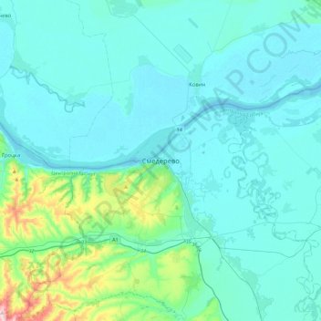
Name: Smederevo topographic map, elevation, terrain.
Average elevation: 105 m
Minimum elevation: 66 m
Maximum elevation: 401 m
Make a donation
Gear up for your next adventure:
As an Amazon Associate, this site earns from qualifying purchases at no extra cost to you.
Other topographic maps
Click on a map to view its topography, its elevation and its terrain.
Smederevska Palanka
Serbia > Central Serbia > Podunavlje Administrative District > Smederevska Palanka Municipality
Average elevation: 143 m
Glibovac
Serbia > Central Serbia > Podunavlje Administrative District > Smederevska Palanka Municipality
Average elevation: 136 m
Make a donation
Gear up for your next adventure:
As an Amazon Associate, this site earns from qualifying purchases at no extra cost to you.
Golobok
Serbia > Central Serbia > Podunavlje Administrative District > Smederevska Palanka Municipality
Average elevation: 155 m
Azanja
Serbia > Central Serbia > Podunavlje Administrative District > Smederevska Palanka Municipality
Average elevation: 163 m
Velika Plana
Serbia > Central Serbia > Podunavlje Administrative District > Velika Plana Municipality
Average elevation: 125 m
Make a donation
Gear up for your next adventure:
As an Amazon Associate, this site earns from qualifying purchases at no extra cost to you.
Selevac
Serbia > Central Serbia > Podunavlje Administrative District > Smederevska Palanka Municipality
Average elevation: 177 m
Velika Plana Municipality
Serbia > Central Serbia > Podunavlje Administrative District
Average elevation: 141 m
Make a donation
Gear up for your next adventure:
As an Amazon Associate, this site earns from qualifying purchases at no extra cost to you.