Geolocate

Junction topographic map

Click on the map to display elevation.

About this map

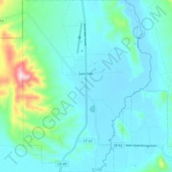
Name: Junction topographic map, elevation, terrain.

Location: Junction, Piute County, Utah, 84740, United States (38.19758 -112.25258 38.26694 -112.18630)

Average elevation: 1,891 m

Minimum elevation: 1,817 m

Maximum elevation: 2,295 m

Other topographic maps

Click on a map to view its topography, its elevation and its terrain.

Phonolite Hill

United States > Utah > Piute County

Average elevation: 2,098 m

Gear up for your next adventure:

🔭Outdoor Binoculars - Lightweight binoculars for birdwatching and hiking
🌬️Windproof Camp Stove - Efficient cooking even on exposed mountain peaks
🧦Thermal Socks - Warm socks for winter hiking or camping
🏕️Camping Hammock - Integrated protection for sleeping between trees
🔥Emergency Fire Starter - Reliable ignition source for all weather conditions

As an Amazon Associate, this site earns from qualifying purchases at no extra cost to you.