
Alausí topographic map
Click on the map to display elevation.
Alausí
Alausi is located at an average altitude of 2,340 meters (7,677 feet) above sea level. The lowest level in the canton is 1,225 meters (4,019 feet) above sea level, in the Huigra parish and the highest is 3,340 meters (10,958 feet) above sea level in Achupallas.
About this map
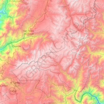
Name: Alausí topographic map, elevation, terrain.
Location: Alausí, Chimborazo, Ecuador (-2.56733 -79.09107 -2.08275 -78.46211)
Average elevation: 3,276 m
Minimum elevation: 993 m
Maximum elevation: 4,606 m
Other topographic maps
Click on a map to view its topography, its elevation and its terrain.