
Piauí topographic map
Click on the map to display elevation.
About this map
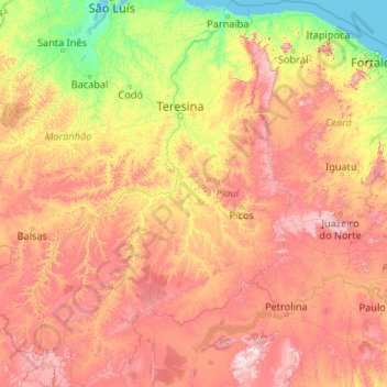
Name: Piauí topographic map, elevation, terrain.
Location: Piauí, Northeast Region, Brazil (-10.92806 -46.02711 -2.57070 -40.37051)
Average elevation: 321 m
Minimum elevation: 0 m
Maximum elevation: 1,250 m
Other topographic maps
Click on a map to view its topography, its elevation and its terrain.
Parque Rita Lee
Brazil > Rio de Janeiro > Região Metropolitana do Rio de Janeiro > Rio de Janeiro
Average elevation: 4 m
Fazenda Rio Grande
Brazil > Paraná > Região Metropolitana de Curitiba > Fazenda Rio Grande
Average elevation: 906 m