
Thank you for supporting this site ❤️
Make a donation
Make a donation
Gear up for your next adventure:
As an Amazon Associate, this site earns from qualifying purchases at no extra cost to you.
Hänigsen topographic map
Click on the map to display elevation.
Thank you for supporting this site ❤️
Make a donation
Make a donation
Gear up for your next adventure:
As an Amazon Associate, this site earns from qualifying purchases at no extra cost to you.
About this map
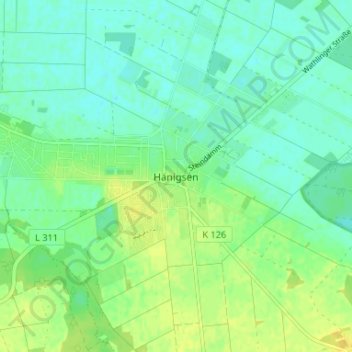
Name: Hänigsen topographic map, elevation, terrain.
Location: Hänigsen, Uetze, Region Hannover, Niedersachsen, Deutschland (52.46358 10.07702 52.50358 10.11702)
Average elevation: 48 m
Minimum elevation: 40 m
Maximum elevation: 59 m
Thank you for supporting this site ❤️
Make a donation
Make a donation
Gear up for your next adventure:
As an Amazon Associate, this site earns from qualifying purchases at no extra cost to you.