Geolocate

Fisterra topographic map

Click on the map to display elevation.

About this map

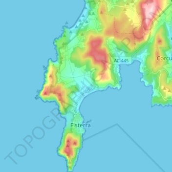
Name: Fisterra topographic map, elevation, terrain.

Location: Fisterra, A Coruña, Galicia, Spain (42.87990 -9.29873 42.97718 -9.22058)

Average elevation: 38 m

Minimum elevation: 0 m

Maximum elevation: 289 m

Other topographic maps

Click on a map to view its topography, its elevation and its terrain.

Lires

Spain > Galicia > Fisterra > Cee

Average elevation: 63 m

Fisterra

Spain > Galicia > Fisterra

Average elevation: 20 m

Gear up for your next adventure:

🛰️Satellite Messenger - Emergency communication for areas with no cell service
🔦LED Flashlight - Powerful and long-lasting flashlight for camping and emergencies
💧Reusable Water Bottle - Durable water bottles for hydration on trails
🦌Outdoor Trail Camera - Monitor wildlife activity near your favorite spots
🛏️Camping Sleeping Mat - Comfortable mats for sleeping outdoors

As an Amazon Associate, this site earns from qualifying purchases at no extra cost to you.