
Molloco topographic map
Click on the map to display elevation.
About this map
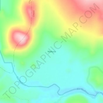
Name: Molloco topographic map, elevation, terrain.
Location: Molloco, Choco, Castilla, Arequipa, Perú (-15.26627 -72.06610 -15.22627 -72.02610)
Average elevation: 4,538 m
Minimum elevation: 4,438 m
Maximum elevation: 4,723 m
Other topographic maps
Click on a map to view its topography, its elevation and its terrain.
Valle del Colca
Perú > Arequipa > Choco > Soro
El Altiplano en el Colca está representado por una extensa meseta que se desarrolla a altitudes entre 4000 y 4500 m s. n. m.. Ésta es una superficie casi llana o suavemente ondulada, sobre la cual destacan cerros y volcanes que sobrepasan los 5000 m s. n. m.. Es en estas superficies donde sobresalen volcanes…
Average elevation: 3,169 m