
Krakow topographic map
Click on the map to display elevation.
About this map
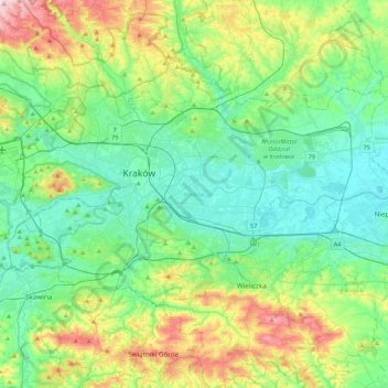
Name: Krakow topographic map, elevation, terrain.
Location: Krakow, Lesser Poland Voivodeship, Poland (49.96767 19.79224 50.12613 20.21735)
Average elevation: 258 m
Minimum elevation: 187 m
Maximum elevation: 457 m
Other topographic maps
Click on a map to view its topography, its elevation and its terrain.
Rysy
Poland > Lesser Poland Voivodeship > Tatra County > Brzegi
It is possible to reach the peak from the Slovak side, starting at Štrbské pleso and passing Chata pod Rysmi, a mountain chalet at an altitude of 2,250 m (7,380 ft). Between November 1 and June 15, the trail and chalet on the Slovak side are closed.
Average elevation: 2,005 m