
Make a donation
Gear up for your next adventure:
As an Amazon Associate, this site earns from qualifying purchases at no extra cost to you.
Gressenich topographic map
Click on the map to display elevation.
Make a donation
Gear up for your next adventure:
As an Amazon Associate, this site earns from qualifying purchases at no extra cost to you.
Gressenich
Höhepunkte des Gressenicher Karnevals sind der alljährliche Karnevalsfreitag im Festzelt auf dem Marktplatz und der große Karnevalsumzug am Sonntag.
Make a donation
Gear up for your next adventure:
As an Amazon Associate, this site earns from qualifying purchases at no extra cost to you.
About this map
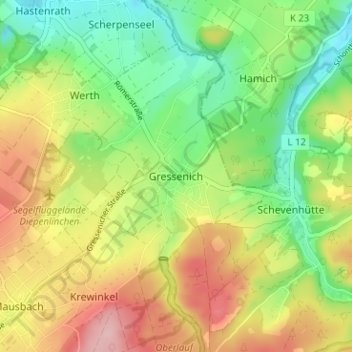
Name: Gressenich topographic map, elevation, terrain.
Average elevation: 236 m
Minimum elevation: 165 m
Maximum elevation: 327 m
Make a donation
Gear up for your next adventure:
As an Amazon Associate, this site earns from qualifying purchases at no extra cost to you.
Other topographic maps
Click on a map to view its topography, its elevation and its terrain.
Vichtbachtal mit Grölis-, Schlee- und Lensbach
Deutschland > Nordrhein-Westfalen > Städteregion Aachen > Stolberg > Vicht
Average elevation: 376 m