
Thank you for supporting this site ❤️
Make a donation
Make a donation
Gear up for your next adventure:
As an Amazon Associate, this site earns from qualifying purchases at no extra cost to you.
Şanlıurfa topographic map
Click on the map to display elevation.
Thank you for supporting this site ❤️
Make a donation
Make a donation
Gear up for your next adventure:
As an Amazon Associate, this site earns from qualifying purchases at no extra cost to you.
About this map
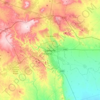
Name: Şanlıurfa topographic map, elevation, terrain.
Location: Şanlıurfa, Southeastern Anatolia Region, 63100, Turkey (36.98939 38.63021 37.30939 38.95021)
Average elevation: 618 m
Minimum elevation: 383 m
Maximum elevation: 953 m
Thank you for supporting this site ❤️
Make a donation
Make a donation
Gear up for your next adventure:
As an Amazon Associate, this site earns from qualifying purchases at no extra cost to you.