Geolocate

Bristow topographic map

Click on the map to display elevation.

About this map

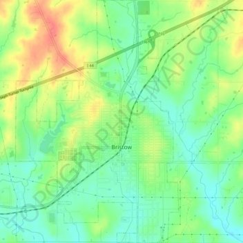
Name: Bristow topographic map, elevation, terrain.

Location: Bristow, Creek County, Oklahoma, United States (35.81368 -96.41431 35.85733 -96.36938)

Average elevation: 253 m

Minimum elevation: 229 m

Maximum elevation: 288 m

Gear up for your next adventure:

💧Collapsible Water Bottle - Space-saving water bottle for outdoor activities
🧢Sun Hat - Wide-brim hat for sun protection
🚑Survival Whistle - Signal for help across long distances in mountains
💡Portable Camping Lamp - Rechargeable lamp for campsite lighting
🧢Hiking Hat - Sun-protective and breathable hats for long treks

As an Amazon Associate, this site earns from qualifying purchases at no extra cost to you.