Geolocate

Stadionberg topographic map

Click on the map to display elevation.

About this map

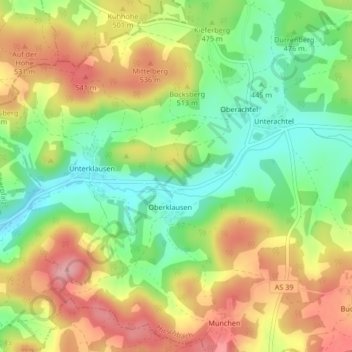
Name: Stadionberg topographic map, elevation, terrain.

Location: Stadionberg, Oberklausen, Hirschbach, Königstein (VGem), Landkreis Amberg-Sulzbach, Bayern, 92275, Deutschland (49.56649 11.57396 49.56820 11.57613)

Average elevation: 478 m

Minimum elevation: 410 m

Maximum elevation: 555 m

Other topographic maps

Click on a map to view its topography, its elevation and its terrain.

Gear up for your next adventure:

🧭GPS Outdoor Watch - Smart watch for navigation and fitness tracking in nature
🧼Travel Hand Sanitizer - Keep hands clean when water is scarce
Bushcraft Tarp - Versatile emergency shelter or gear protection
🥽Outdoor Goggles - Protective eyewear for outdoor activities
🐕Hiking Dog Pack - Let your canine companion carry their own water and food

As an Amazon Associate, this site earns from qualifying purchases at no extra cost to you.