Geolocate

Hirmes topographic map

Click on the map to display elevation.

About this map

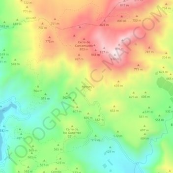
Name: Hirmes topographic map, elevation, terrain.

Location: Hirmes, Berja, Almería, Andalucía, España (36.87294 -3.01806 36.91294 -2.97806)

Average elevation: 597 m

Minimum elevation: 326 m

Maximum elevation: 926 m

Other topographic maps

Click on a map to view its topography, its elevation and its terrain.

Río Adra

España > Andalucía > Berja

Average elevation: 270 m

Gear up for your next adventure:

🥾Trail Running Boots - Durable shoes designed for trail running
Family Camping Tent - Spacious tent suitable for family camping trips
🚲Handlebar Phone Mount - View topographic-map.com live while cycling
🧥Waterproof Jacket - Lightweight rain jackets for hiking and outdoor activities
🧢Outdoor Cap - Protective cap for sun and rain during hikes

As an Amazon Associate, this site earns from qualifying purchases at no extra cost to you.