
Make a donation
Gear up for your next adventure:
As an Amazon Associate, this site earns from qualifying purchases at no extra cost to you.
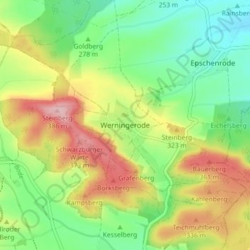
Werningerode topographic map
Click on the map to display elevation.
Make a donation
Gear up for your next adventure:
As an Amazon Associate, this site earns from qualifying purchases at no extra cost to you.
Werningerode
Der Ort Werningerode befindet sich im östlichen Teil des Landkreises, etwa 22 Kilometer (Luftlinie) nordöstlich der Kreisstadt Heilbad Heiligenstadt. Das Dorf liegt in einem Talkessel, der vom Wiesengraben durchflossen wird. Südlich, westlich und östlich grenzt die Gemarkung an das Schwarzburger Holz. Nach Norden hin ist der Talkessel von einem landwirtschaftlich genutzten Höhenzug umgeben. Als höchste Erhebung gilt der Steinberg (385,5 m ü. NN), erwähnenswert sind auch der Schwarzburger Warte (373,4 m ü. NN) und der Bauerberg (361,6 m ü. NN).
Make a donation
Gear up for your next adventure:
As an Amazon Associate, this site earns from qualifying purchases at no extra cost to you.
About this map
Name: Werningerode topographic map, elevation, terrain.
Average elevation: 295 m
Minimum elevation: 224 m
Maximum elevation: 397 m
Make a donation
Gear up for your next adventure:
As an Amazon Associate, this site earns from qualifying purchases at no extra cost to you.
Other topographic maps
Click on a map to view its topography, its elevation and its terrain.
Weißenborn-Lüderode
Deutschland > Thüringen > Landkreis Eichsfeld > Sonnenstein
Average elevation: 271 m
Make a donation
Gear up for your next adventure:
As an Amazon Associate, this site earns from qualifying purchases at no extra cost to you.