
Make a donation
Gear up for your next adventure:
As an Amazon Associate, this site earns from qualifying purchases at no extra cost to you.
Braunenberg topographic map
Click on the map to display elevation.
Make a donation
Gear up for your next adventure:
As an Amazon Associate, this site earns from qualifying purchases at no extra cost to you.
Braunenberg
Der Braunenberg ist ein 685,3 m ü. NHN hoher Berg östlich des Aalener Stadtbezirks Wasseralfingen auf der Ostalb. Er ist die markanteste Erhebung des Höhenzuges Flexner (48° 52′ N, 10° 8′ O48.86027777777810.140277777778725.4, 725,4 m ü. NHN), dem er vorgelagert ist.
Make a donation
Gear up for your next adventure:
As an Amazon Associate, this site earns from qualifying purchases at no extra cost to you.
About this map
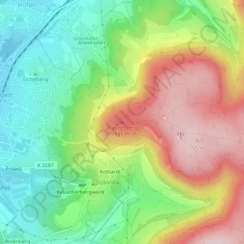
Name: Braunenberg topographic map, elevation, terrain.
Average elevation: 559 m
Minimum elevation: 428 m
Maximum elevation: 731 m
Make a donation
Gear up for your next adventure:
As an Amazon Associate, this site earns from qualifying purchases at no extra cost to you.
Other topographic maps
Click on a map to view its topography, its elevation and its terrain.
Make a donation
Gear up for your next adventure:
As an Amazon Associate, this site earns from qualifying purchases at no extra cost to you.