Geolocate

De la Paz topographic map

Click on the map to display elevation.

About this map

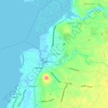
Name: De la Paz topographic map, elevation, terrain.

Location: De la Paz, Cortes, Bohol, Central Visayas, 6341, Philippines (9.67809 123.84805 9.71809 123.88805)

Average elevation: 20 m

Minimum elevation: -4 m

Maximum elevation: 82 m

Gear up for your next adventure:

🧴Outdoor Sunscreen - High SPF protection for high-altitude UV exposure
🛶Waterproof Dry Bags - Keep electronics and clothes dry during river crossings
🔦LED Headtorch - Bright and durable light for night activities
👖Convertible Hiking Pants - Zip-off legs to adapt to changing weather conditions
🥾Trail Hiking Socks - Comfortable socks to prevent blisters and fatigue

As an Amazon Associate, this site earns from qualifying purchases at no extra cost to you.