Geolocate

Monte Cusna topographic map

Click on the map to display elevation.

Monte Cusna

The mountain is located along the Appennino Crest Trail (A00) between Cerreto and Lagastrello Passes, with an altitude of 2,120 metres (6,960 ft). It is also known as Uomo Morto (Italian: "Dead Man"), "Uomo che Dorme" ("Sleeping Man") or "Il Gigante" ("The Giant") for its appearance, resembling a lying man.

Wikipedia (CC-BY-SA 3.0)

About this map

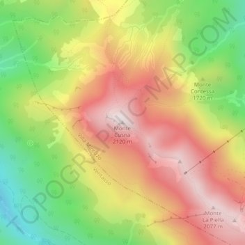
Name: Monte Cusna topographic map, elevation, terrain.

Location: Monte Cusna, Villa Minozzo, Appennino Reggiano, Reggio nell'Emilia, Emilia-Romagna, Italy (44.28776 10.39153 44.28786 10.39163)

Average elevation: 1,721 m

Minimum elevation: 1,313 m

Maximum elevation: 2,090 m

Gear up for your next adventure:

🛶Kayak Dry Bag - Waterproof storage for kayaking adventures
🔥Emergency Fire Starter - Reliable ignition source for all weather conditions
🥾Light Trekking Boots - Supportive boots for multi-day treks
🧥Thermal Fleece Jacket - Versatile insulation for changing mountain temperatures
🧦Outdoor Socks - Durable socks designed for hiking and outdoor sports

As an Amazon Associate, this site earns from qualifying purchases at no extra cost to you.