Geolocate

Grumbach topographic map

Click on the map to display elevation.

About this map

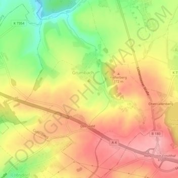
Name: Grumbach topographic map, elevation, terrain.

Location: Grumbach, Callenberg, Zwickau, Sachsen, Deutschland (50.81495 12.61038 50.84342 12.64757)

Average elevation: 349 m

Minimum elevation: 276 m

Maximum elevation: 401 m

Other topographic maps

Click on a map to view its topography, its elevation and its terrain.

Kapellenberg

Deutschland > Sachsen > Zwickau > Callenberg

Average elevation: 408 m

Callenberg Nord II

Deutschland > Sachsen > Zwickau > Callenberg

Average elevation: 306 m

Langenberger Höhe

Deutschland > Sachsen > Zwickau > Callenberg

Average elevation: 425 m

Obercallenberg

Deutschland > Sachsen > Zwickau > Callenberg

Average elevation: 357 m

Kahleberg

Deutschland > Sachsen > Zwickau > Callenberg

Average elevation: 319 m

Gear up for your next adventure:

🧣Merino Neck Gaiter - Protects against wind, sun, and cold at high altitudes
🎒Fully Waterproof Backpack - Total protection for photography gear and electronics
🎒Backpack Rain Cover - External shield to keep your entire pack dry
🧥Waterproof Hiking Jacket - Protect yourself from rain and wind while hiking
Family Camping Tent - Spacious tent suitable for family camping trips

As an Amazon Associate, this site earns from qualifying purchases at no extra cost to you.