
Schwende-Rüte topographic map
Interactive map
Click on the map to display elevation.
About this map
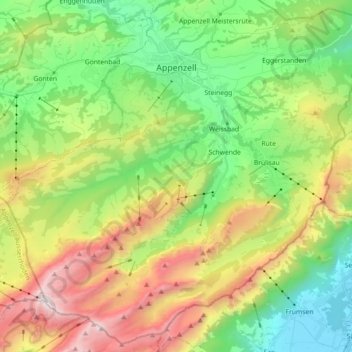
Name: Schwende-Rüte topographic map, elevation, terrain.
Location: Schwende-Rüte, Appenzell Rhodes-Intérieures, Suisse (47.23400 9.32321 47.35026 9.50302)
Average elevation: 1,192 m
Minimum elevation: 435 m
Maximum elevation: 2,480 m
Other topographic maps
Click on a map to view its topography, its elevation and its terrain.
Schwende
Suisse > Appenzell Rhodes-Intérieures > Schwende-Rüte
Schwende, Schwende-Rüte, Appenzell Rhodes-Intérieures, 9057, Suisse
Average elevation: 1,279 m
Oberegg
Suisse > Appenzell Rhodes-Intérieures
Oberegg, Appenzell Rhodes-Intérieures, 9413, Suisse
Average elevation: 779 m
Brülisau
Suisse > Appenzell Rhodes-Intérieures > Schwende-Rüte
Rüte, Brülisau, Schwende-Rüte, Appenzell Rhodes-Intérieures, 9050, Suisse
Average elevation: 1,006 m
Appenzell
Suisse > Appenzell Rhodes-Intérieures
Appenzell, Appenzell Rhodes-Intérieures, 9050, Suisse
Average elevation: 940 m