Geolocate

Parwa topographic map

Click on the map to display elevation.

About this map

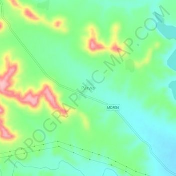
Name: Parwa topographic map, elevation, terrain.

Location: Parwa, Pusad, Yavatmal District, Maharashtra, India (19.98622 77.40138 20.02622 77.44138)

Average elevation: 424 m

Minimum elevation: 376 m

Maximum elevation: 524 m

Gear up for your next adventure:

🔋Lithium AA Batteries - Long-lasting power that performs in extreme cold
🔦UV Flashlight - Detect minerals or specific insects in the dark
🩹Compact First Aid Kit - Pre-packed essentials for common trail injuries
🥾Light Trekking Boots - Supportive boots for multi-day treks
🧰Emergency Multi-Tool - Compact multi-tool for outdoor survival

As an Amazon Associate, this site earns from qualifying purchases at no extra cost to you.