Geolocate

Varzo topographic map

Click on the map to display elevation.

About this map

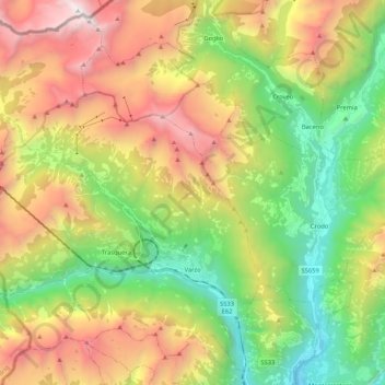
Name: Varzo topographic map, elevation, terrain.

Location: Varzo, Verbano-Cusio-Ossola, Piedmont, Italy (46.16827 8.08050 46.30345 8.29111)

Average elevation: 1,533 m

Minimum elevation: 313 m

Maximum elevation: 3,251 m

Other topographic maps

Click on a map to view its topography, its elevation and its terrain.

Falmenta

Italy > Piedmont > Verbano-Cusio-Ossola

Average elevation: 840 m

Coimo

Italy > Piedmont > Verbano-Cusio-Ossola

Average elevation: 1,087 m

Socraggio

Italy > Piedmont > Verbano-Cusio-Ossola > Cannobio

Average elevation: 808 m

Preglia

Italy > Piedmont > Verbano-Cusio-Ossola

Average elevation: 470 m

Isola Bella

Italy > Piedmont > Verbano-Cusio-Ossola > Carciano

Average elevation: 227 m

Gear up for your next adventure:

🧴Waterproofing Spray - Restore the DWR coating on jackets and tents
🚲Heavy Duty Bike Lock - Secure your bike at the trailhead or during stops
🪑Ultralight Camping Stool - Compact seating for rest stops during long hikes
🧥Softshell Jacket - Windproof and breathable jacket for hiking
🦶Anti-Blister Balm - Prevents friction and hotspots during long ascents

As an Amazon Associate, this site earns from qualifying purchases at no extra cost to you.