Geolocate

Mercoeur topographic map

Click on the map to display elevation.

About this map

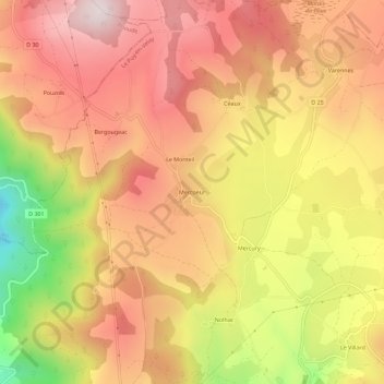
Name: Mercoeur topographic map, elevation, terrain.

Location: Mercoeur, Saint-Privat-d'Allier, Le Puy-en-Velay, Haute-Loire, Auvergne-Rhône-Alpes, France métropolitaine, 43580, France (44.99128 3.64462 45.03128 3.68462)

Average elevation: 1,009 m

Minimum elevation: 647 m

Maximum elevation: 1,234 m

Other topographic maps

Click on a map to view its topography, its elevation and its terrain.

Gear up for your next adventure:

🧴First Aid Kit - Essential first aid supplies for outdoor emergencies
🧥Packable Rain Jacket - Breathable waterproof layer for unpredictable weather
🧢Outdoor Cap - Protective cap for sun and rain during hikes
🥾Hiking Shoes - Durable and comfortable shoes for trail hiking
🥾Mountaineering Boots - Supportive boots for climbing and high-altitude hiking

As an Amazon Associate, this site earns from qualifying purchases at no extra cost to you.