
Niort topographic map
Click on the map to display elevation.
About this map
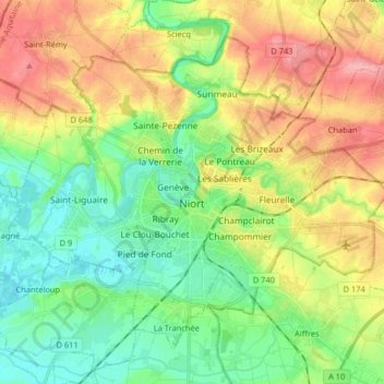
Name: Niort topographic map, elevation, terrain.
Average elevation: 39 m
Minimum elevation: 1 m
Maximum elevation: 94 m
Other topographic maps
Click on a map to view its topography, its elevation and its terrain.
Le Bois Chapeleau
France > Nouvelle-Aquitaine > Deux-Sèvres > Beugnon-Thireuil
Average elevation: 120 m
Seche Bec
France > Nouvelle-Aquitaine > Deux-Sèvres > Niort > Le Petit Chauveux
Average elevation: 47 m