
Thank you for supporting this site ❤️
Make a donation
Make a donation
Gear up for your next adventure:
As an Amazon Associate, this site earns from qualifying purchases at no extra cost to you.
Jupapina topographic map
Click on the map to display elevation.
Thank you for supporting this site ❤️
Make a donation
Make a donation
Gear up for your next adventure:
As an Amazon Associate, this site earns from qualifying purchases at no extra cost to you.
About this map
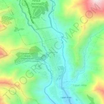
Name: Jupapina topographic map, elevation, terrain.
Location: Jupapina, Mecapaca, Pedro Domingo Murillo, La Paz, Bolivia (-16.61495 -68.09138 -16.57495 -68.05138)
Average elevation: 3,263 m
Minimum elevation: 3,011 m
Maximum elevation: 3,804 m
Thank you for supporting this site ❤️
Make a donation
Make a donation
Gear up for your next adventure:
As an Amazon Associate, this site earns from qualifying purchases at no extra cost to you.
Other topographic maps
Click on a map to view its topography, its elevation and its terrain.