Geolocate

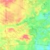
Sugar Grove topographic map

Click on the map to display elevation.

About this map

Name: Sugar Grove topographic map, elevation, terrain.

Location: Sugar Grove, Sugar Grove Township, Kane County, Illinois, 60554, United States (41.72903 -88.51325 41.80539 -88.39739)

Average elevation: 214 m

Minimum elevation: 198 m

Maximum elevation: 232 m

Other topographic maps

Click on a map to view its topography, its elevation and its terrain.
Elgin

United States > Illinois > Kane County

Average elevation: 255 m

Elgin

United States > Illinois > Kane County

Average elevation: 255 m

Campton Township

United States > Illinois > Kane County

Average elevation: 267 m

Gear up for your next adventure:

🧢Beanie Hat - Keep your head warm in cold weather
🔋Lithium AA Batteries - Long-lasting power that performs in extreme cold
🧥Softshell Hiking Jacket - The perfect balance of wind protection and breathability
🥾Mountain Hiking Shoes - Shoes with superior grip for mountainous terrain
🥾Hiking Boots - Sturdy boots providing ankle support and traction on rugged trails

As an Amazon Associate, this site earns from qualifying purchases at no extra cost to you.