Geolocate

Bagabag topographic map

Click on the map to display elevation.

About this map

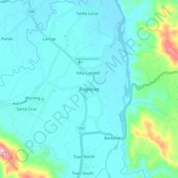
Name: Bagabag topographic map, elevation, terrain.

Location: Bagabag, Nueva Vizcaya, Cagayan Valley, 3711, Philippines (16.56554 121.21331 16.64554 121.29331)

Average elevation: 262 m

Minimum elevation: 204 m

Maximum elevation: 592 m

Other topographic maps

Click on a map to view its topography, its elevation and its terrain.

Kasibu River

Philippines > Nueva Vizcaya > Kasibu

Average elevation: 866 m

Kayapa

Philippines > Nueva Vizcaya

Average elevation: 1,258 m

Gear up for your next adventure:

Backpacking Tent - Lightweight tent for long-distance hiking trips
🚑Survival Whistle - Signal for help across long distances in mountains
🧢Hiking Sun Hat - Wide-brimmed protection for exposed mountain ridges
🥽Outdoor Goggles - Protective eyewear for outdoor activities
🧼Biodegradable Camp Soap - Environmentally friendly cleaning for gear and body

As an Amazon Associate, this site earns from qualifying purchases at no extra cost to you.