
Hammarby topographic map
Click on the map to display elevation.
About this map
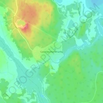
Name: Hammarby topographic map, elevation, terrain.
Location: Hammarby, Sandvikens kommun, Gävleborgs län, 812 41, Sverige (60.52506 16.55395 60.56506 16.59395)
Average elevation: 78 m
Minimum elevation: 58 m
Maximum elevation: 125 m
Other topographic maps
Click on a map to view its topography, its elevation and its terrain.
Ljusdals kommun
Området som utgör Ljusdals kommun är kuperat med höjder på 400–600 meter över havet. Genom kommunen rinner Ljusnan. I början av 2020-talet var kommunen själv den största arbetsgivaren. En förhållandevis stor andel var sysselsatta inom jord- och skogsbruk och besöksnäringen höll på att…
Average elevation: 315 m
Nordanstigs kommun
Längs kusten finns en milsbred remsa som är låglänt. Den övergår längre in i en storkuperad urbergsterräng. I väster når höjderna cirka 500 meter över havet. 90 procent av kommunens yta består av skog. Under lång tid har skogsindustrin varit viktig för det lokala näringslivet, den största…
Average elevation: 137 m
Bollnäs kommun
Genomgående är terrängen storbruten även om detta är tydligare i den västra delen än den östra. Höjderna är beväxta med skog, medan odlings- och betesmarker primärt återfinns vid Ljusnans och Voxnans älvsystem. Tjänstesektorn dominerade kommunens näringsliv i början av 2020-talet.
Average elevation: 189 m
Hofors kommun
Området som utgör kommunen är beläget inom bergslagen och där finns således en del malmfyndigheter. Järnmalm har brutits i Stillgruvan och Storgruvan norr om sjön Stor-Gösken från medeltiden till början av 1900-talet. Kuperade, skogklädda moränområden finns i väster och i öster finns Torsåker…
Average elevation: 147 m
Hudiksvalls kommun
Berggrunden riktning har gjort att dalar och höjder har en nordvästlig–sydöstlig riktning, vilket är fallet i många norrlandskommuner. Kusten mellan Hudiksvall och Enånger har dock en öst–västlig riktning med branta, utstickande uddar. För cirka 220–250 miljoner år sedan slog en meteorit ned i…
Average elevation: 95 m
Sandvikens kommun
Dalälvens nedre lopp dominerar södra delarna av den kuperade skogskommunen Sandviken. Gnejs, granit och amfibolit utgör huvudsakligen dess berggrund. De delar av området som ligger på högre höjder är i regel täckta med morän och bevuxna med barrskog. Moränen kan, speciellt i väster, vara…
Average elevation: 108 m
Bergviken
Sverige > Gävleborgs län > Skog
Bergviken ingår i delavrinningsområde (679004-155006) som SMHI kallar för Utloppet av Bergviken. Medelhöjden är 74 meter över havet och ytan är 101,06 kvadratkilometer. Räknas de 2088 avrinningsområdena uppströms in blir den ackumulerade arean 19 611,76 kvadratkilometer. Avrinningsområdets utflöde…
Average elevation: 98 m