
Hawai'i Volcanoes National Park topographic map
Interactive map
Click on the map to display elevation.
About this map
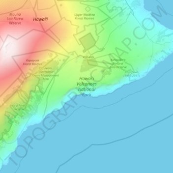
Name: Hawai'i Volcanoes National Park topographic map, elevation, terrain.
Average elevation: 688 m
Minimum elevation: 0 m
Maximum elevation: 4,163 m
Other topographic maps
Click on a map to view its topography, its elevation and its terrain.
Mauna Kea
United States of America (Island of Hawai'i territorial waters) > Hawaï > Hilo
Mauna Kea, Hilo, Hawaiʻi County, Hawaï, United States of America (Island of Hawai'i territorial waters)
Average elevation: 3,979 m