Geolocate

Donie topographic map

Click on the map to display elevation.

About this map
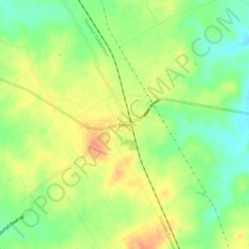
Name: Donie topographic map, elevation, terrain.

Location: Donie, Freestone County, Texas, 75838, United States (31.45737 -96.24308 31.49737 -96.20308)

Average elevation: 143 m

Minimum elevation: 121 m

Maximum elevation: 164 m

Other topographic maps

Click on a map to view its topography, its elevation and its terrain.
Fairfield

United States > Texas > Freestone County

Average elevation: 138 m

Wortham

United States > Texas > Freestone County

Average elevation: 142 m

Teague

United States > Texas > Freestone County

Average elevation: 146 m

Teague

United States > Texas > Freestone County

Average elevation: 146 m

Kirvin

United States > Texas > Freestone County

Average elevation: 135 m

Wortham

United States > Texas > Freestone County

Average elevation: 142 m

Gear up for your next adventure:

🚲Bike Repair Kit - Essential tools for on-trail mechanical issues
🥾Waterproof Hiking Shoes - Durable shoes for wet and rugged trails
🧥Waterproof Hiking Jacket - Protect yourself from rain and wind while hiking
🧢Beanie Hat - Keep your head warm in cold weather
💧Reusable Water Bottle - Durable water bottles for hydration on trails

As an Amazon Associate, this site earns from qualifying purchases at no extra cost to you.