Geolocate

Gongri topographic map

Click on the map to display elevation.

About this map

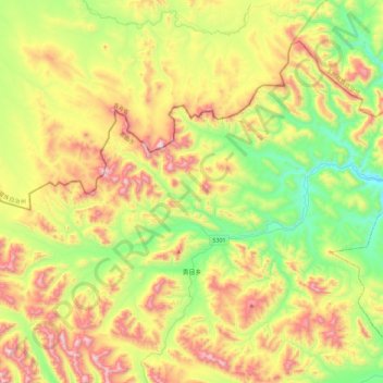
Name: Gongri topographic map, elevation, terrain.

Location: Gongri, Baqên County, Nagqu City, Tibet, China (32.33202 94.31488 32.71538 94.77175)

Average elevation: 4,952 m

Minimum elevation: 4,536 m

Maximum elevation: 5,579 m

Gear up for your next adventure:

🔥Camping Stove - Portable stoves to cook outdoors with ease
💡Portable Camping Lamp - Rechargeable lamp for campsite lighting
🔨Vehicle Emergency Tool - Safety tool for remote road trips to trailheads
🧰Survival Kit - Essential gear for emergencies in the wilderness
💡Solar Camping Lamp - Eco-friendly lighting for campsites

As an Amazon Associate, this site earns from qualifying purchases at no extra cost to you.