
Thank you for supporting this site ❤️
Make a donation
Make a donation
Gear up for your next adventure:
As an Amazon Associate, this site earns from qualifying purchases at no extra cost to you.
平田村 topographic map
Click on the map to display elevation.
Thank you for supporting this site ❤️
Make a donation
Make a donation
Gear up for your next adventure:
As an Amazon Associate, this site earns from qualifying purchases at no extra cost to you.
About this map
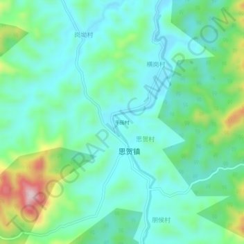
Name: 平田村 topographic map, elevation, terrain.
Location: 平田村, Xinyi City, Maoming City, Guangdong Province, China (22.45668 111.55075 22.49668 111.59075)
Average elevation: 206 m
Minimum elevation: 122 m
Maximum elevation: 466 m
Thank you for supporting this site ❤️
Make a donation
Make a donation
Gear up for your next adventure:
As an Amazon Associate, this site earns from qualifying purchases at no extra cost to you.