
Sweikhuizen topographic map
Interactive map
Click on the map to display elevation.
About this map
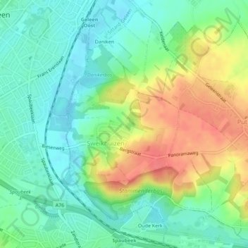
Name: Sweikhuizen topographic map, elevation, terrain.
Location: Sweikhuizen, Beekdaelen, Limburg, Nederland (50.94464 5.83956 50.96613 5.86467)
Average elevation: 77 m
Minimum elevation: 53 m
Maximum elevation: 114 m
Other topographic maps
Click on a map to view its topography, its elevation and its terrain.
Schinnen
Nederland > Limburg > Beekdaelen
Schinnen, Beekdaelen, Limburg, Nederland
Average elevation: 92 m
Hulsberg
Nederland > Limburg > Beekdaelen > Hulsberg
Hulsberg, Beekdaelen, Limburg, Nederland
Average elevation: 122 m
Schimmert
Nederland > Limburg > Beekdaelen
Schimmert, Beekdaelen, Limburg, Nederland
Average elevation: 127 m
Schinveld
Nederland > Limburg > Beekdaelen
Schinveld, Beekdaelen, Limburg, Nederland
Average elevation: 72 m