Geolocate

La Répara-Auriples topographic map

Click on the map to display elevation.

About this map

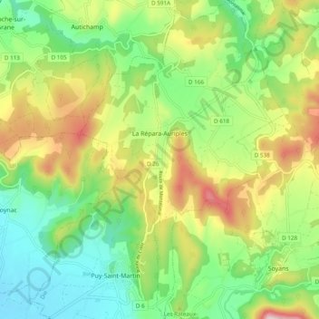
Name: La Répara-Auriples topographic map, elevation, terrain.

Location: La Répara-Auriples, Die, Drôme, Auvergne-Rhône-Alpes, Metropolitan France, 26400, France (44.61910 4.96253 44.68742 5.02415)

Average elevation: 330 m

Minimum elevation: 174 m

Maximum elevation: 585 m

Other topographic maps

Click on a map to view its topography, its elevation and its terrain.

Chanos

France > Auvergne-Rhône-Alpes > Drôme

Average elevation: 175 m

Saint-Bardoux

France > Auvergne-Rhône-Alpes > Drôme > Grane

Average elevation: 181 m

Malo

France > Auvergne-Rhône-Alpes > Drôme > Peyrus

Average elevation: 542 m

Limone

France > Auvergne-Rhône-Alpes > Drôme > Crépol

Average elevation: 347 m

Les Fondeaux

France > Auvergne-Rhône-Alpes > Drôme > Die

Average elevation: 516 m

Les Arphons

France > Auvergne-Rhône-Alpes > Drôme > Vesc

Average elevation: 669 m

Gear up for your next adventure:

🛶Kayak Dry Bag - Waterproof storage for kayaking adventures
🚲Bike Repair Kit - Essential tools for on-trail mechanical issues
🛌Insulated Sleeping Pad - Critical thermal barrier between you and the cold ground
🥫Freeze-Dried Meals - Lightweight, high-calorie nutrition for multi-day treks
🔪Outdoor Multitool - Versatile tool for repairs and food prep in the wild

As an Amazon Associate, this site earns from qualifying purchases at no extra cost to you.