
Folgaria topographic map
Click on the map to display elevation.
About this map
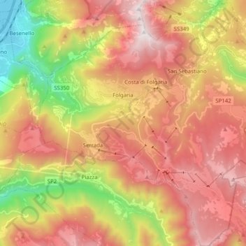
Name: Folgaria topographic map, elevation, terrain.
Average elevation: 1,176 m
Minimum elevation: 174 m
Maximum elevation: 2,012 m
Other topographic maps
Click on a map to view its topography, its elevation and its terrain.
Monte Cornetto
Italy > Trentino – Alto Adige/Südtirol > Provincia di Trento > Trento
Average elevation: 1,659 m
Canale
Italy > Trentino – Alto Adige/Südtirol > Provincia di Trento > Tenno > Ville Del Monte
Average elevation: 709 m
Madonna di Campiglio
Italy > Trentino – Alto Adige/Südtirol > Provincia di Trento
Madonna di Campiglio (German: Sankt Maria im Pein) is a village and a ski resort in northeast Italy. It is a frazione of the comune of Pinzolo. The village lies in the Val Rendena at an elevation of 1,522 m (4,993 ft) above sea level, and has approximately 1,000 inhabitants.
Average elevation: 1,744 m
Lago di Molveno
Italy > Trentino – Alto Adige/Südtirol > Provincia di Trento > Molveno
Average elevation: 1,071 m
Saone
Italy > Trentino – Alto Adige/Südtirol > Provincia di Trento > Tione di Trento
Average elevation: 848 m
Cortina
Italy > Trentino – Alto Adige/Südtirol > Provincia di Trento > Vermiglio
Average elevation: 1,534 m
Biacesa di Ledro
Italy > Trentino – Alto Adige/Südtirol > Provincia di Trento
Average elevation: 831 m
Cortina
Italy > Trentino – Alto Adige/Südtirol > Provincia di Trento > Vermiglio
Average elevation: 1,534 m
Pozza di Fassa - Poza
Italy > Trentino – Alto Adige/Südtirol > Provincia di Trento
Average elevation: 1,583 m
Val di Fiemme
Italy > Trentino – Alto Adige/Südtirol > Provincia di Trento > Panchià
Average elevation: 1,640 m
Covelo
Italy > Trentino – Alto Adige/Südtirol > Provincia di Trento > Vallelaghi
Average elevation: 834 m
Passo Tonale
Italy > Trentino – Alto Adige/Südtirol > Provincia di Trento > Vermiglio
Average elevation: 2,064 m
Alpe Cermis
Italy > Trentino – Alto Adige/Südtirol > Provincia di Trento > Cavalese
Average elevation: 1,715 m
Ronchi
Italy > Trentino – Alto Adige/Südtirol > Provincia di Trento > Trento > Mattarello
Average elevation: 339 m
Madonna di Campiglio
Italy > Trentino – Alto Adige/Südtirol > Provincia di Trento
Madonna di Campiglio (German: Sankt Maria im Pein) is a village and a ski resort in northeast Italy. It is a frazione of the comune of Pinzolo. The village lies in the Val Rendena at an elevation of 1,522 m (4,993 ft) above sea level, and has approximately 1,000 inhabitants.
Average elevation: 1,744 m
Valsorda
Italy > Trentino – Alto Adige/Südtirol > Provincia di Trento > Predazzo
Average elevation: 1,785 m
Karerpass - Jouf de Ciareja - passo Carezza
Italy > Trentino – Alto Adige/Südtirol > Provincia di Trento
Average elevation: 1,869 m
Lago di Lagolo
Italy > Trentino – Alto Adige/Südtirol > Provincia di Trento > Lagolo
Average elevation: 1,004 m
Mazza di Pichea
Italy > Trentino – Alto Adige/Südtirol > Provincia di Trento
Average elevation: 1,467 m
Cortina
Italy > Trentino – Alto Adige/Südtirol > Provincia di Trento > Vermiglio
Average elevation: 1,534 m
Bocca di Valle
Italy > Trentino – Alto Adige/Südtirol > Provincia di Trento > Bondone
Average elevation: 1,258 m
Belvedere
Italy > Trentino – Alto Adige/Südtirol > Provincia di Trento > Pergine Valsugana
Average elevation: 791 m
Dossone
Italy > Trentino – Alto Adige/Südtirol > Provincia di Trento > Caderzone Terme
Average elevation: 1,639 m
Camin
Italy > Trentino – Alto Adige/Südtirol > Provincia di Trento > Ziano di Fiemme
Average elevation: 2,022 m
Carbonare
Italy > Trentino – Alto Adige/Südtirol > Provincia di Trento > San Sebastiano
Average elevation: 1,167 m
Bergner Kreuz - Croce di Forcella Piccola
Italy > Trentino – Alto Adige/Südtirol > Provincia di Trento
Average elevation: 1,433 m
Stavel
Italy > Trentino – Alto Adige/Südtirol > Provincia di Trento > Vermiglio
Average elevation: 1,692 m
valle dell'Anza
Italy > Trentino – Alto Adige/Südtirol > Provincia di Trento > Levico Terme > Selva di Levico > Masi Rossi
Average elevation: 807 m
Pian
Italy > Trentino – Alto Adige/Südtirol > Provincia di Trento > Campitello di Fassa > Campitello di Fassa - Ciampedel
Average elevation: 1,797 m
Vigo di Fassa - Vich
Italy > Trentino – Alto Adige/Südtirol > Provincia di Trento
Average elevation: 1,600 m
Costasavina
Italy > Trentino – Alto Adige/Südtirol > Provincia di Trento > Pergine Valsugana > Susà
Average elevation: 626 m