
Panjakent District topographic map
Interactive map
Click on the map to display elevation.
About this map
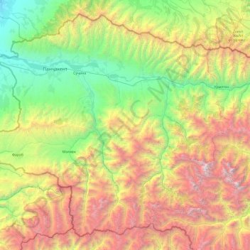
Name: Panjakent District topographic map, elevation, terrain.
Location: Panjakent District, Sughd Region, Tajikistan (38.99626 67.33328 39.65966 68.29608)
Average elevation: 2,425 m
Minimum elevation: 796 m
Maximum elevation: 5,377 m
Other topographic maps
Click on a map to view its topography, its elevation and its terrain.
Khujand
Tajikistan > Sughd Region > Ghafurov District
Khujand, Ghafurov District, Sughd Region, 735700, Tajikistan
Average elevation: 493 m
Spitamen District
Spitamen District, Sughd Region, 735830, Tajikistan
Average elevation: 627 m